
Cities are piloting “smart crosswalk” systems after a rise in near-miss reports involving pedestrians, cyclists, and turning vehicles. The new deployments combine sensors, adaptive signals, and brighter warnings to make crossings more visible and to reduce conflict points—especially at night, in bad weather, and on wide multi-lane roads where drivers may not spot people stepping off the curb.
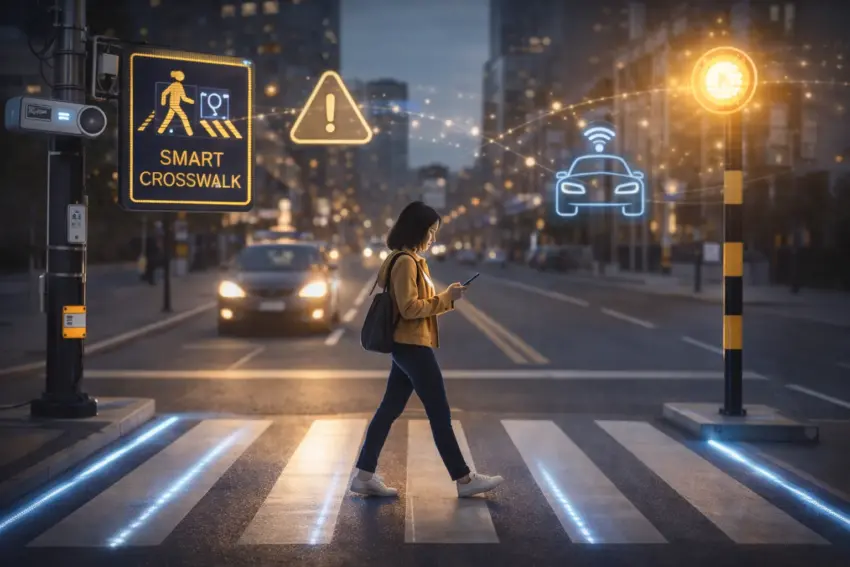
What a “smart crosswalk” is
Smart crosswalks use technology to detect people approaching or entering the crossing and then amplify warnings for drivers and, in some cases, adjust signal timing. The goal is not to replace existing traffic rules, but to make compliance easier and more consistent—particularly in locations with frequent conflicts or poor visibility.
- Pedestrian detection via radar, lidar, thermal cameras, or computer vision.
- Adaptive lighting that brightens the crossing when someone is present.
- In-road LED markers that flash to highlight the crosswalk lines.
- Dynamic signs that activate only when needed, reducing “warning fatigue.”
- Signal priority features such as extended walk phases for slower pedestrians.
Why near-miss reports are rising
Many cities have seen an increase in reported close calls, driven by a combination of factors: heavier delivery traffic, more cycling and e-scooter trips, distracted driving, and higher pedestrian activity around transit hubs and mixed-use districts. Near-miss reporting apps and city hotlines also make it easier for residents to document incidents that previously went unrecorded.
Urban planners note that near misses are often early indicators of risk. A junction that generates repeated “almost accidents” can be a candidate for redesign long before serious injuries occur—making pilots attractive because they can be deployed quickly compared with full reconstruction.
Where pilots are being installed
Early pilots typically target crossings with known safety challenges: multi-lane arterials, intersections with heavy turning movements, routes near schools, and locations with limited street lighting. Cities also prioritize places with documented complaints, recent collision clusters, or traffic patterns that have changed due to construction and detours.
- School zones and routes used by children and older pedestrians.
- Transit corridors with high foot traffic at peak hours.
- Wide intersections where turning vehicles create blind spots.
- Nighttime hotspots around entertainment areas.
- Construction detours where temporary layouts confuse drivers and walkers.
How cities measure whether it works
Because crashes are relatively rare events at a single location, cities often evaluate smart crosswalks using leading indicators: changes in driver yielding, vehicle speeds near the crossing, and the frequency of conflicts captured by sensors or field observation. Many pilots also track resident feedback and maintenance logs to see whether systems remain reliable across seasons.
- Yield rate: how often drivers stop for pedestrians as required.
- Approach speed: whether vehicles slow down near the crossing.
- Conflict events: close passes, hard braking, or late turns recorded by sensors.
- Crossing time: whether pedestrians can complete crossings comfortably.
- System uptime: reliability, false alarms, and maintenance needs.
Benefits—and limits—of tech-based safety
Supporters argue that smart crosswalks can deliver meaningful gains quickly, particularly where visibility is poor or driver compliance is inconsistent. But safety experts caution that technology cannot fully compensate for street designs that encourage high speeds or complicated turning movements. In many cases, the most effective improvements come from a combination of measures: narrower lanes, raised crossings, protected corners, and better signal phasing.
Another challenge is managing false activations. If warnings trigger too often without a real pedestrian present, drivers may begin to ignore them. That is why many pilots emphasize better detection accuracy and context-aware activation instead of constant flashing.
Privacy and data questions
Some systems rely on cameras or advanced sensors, raising questions about data retention and surveillance. Cities that deploy camera-based detection often say they can process video in real time without storing personally identifiable footage, but policies vary. Public communication and clear rules on data handling are increasingly seen as prerequisites for wider rollout.
Bottom line
Smart crosswalk pilots reflect a broader shift toward using near-miss data and rapid deployments to prevent serious crashes before they happen. If the systems improve yielding and slow traffic where conflicts are frequent, cities may expand them—especially near schools and transit hubs. The strongest results, however, are likely when technology is paired with street design changes that reduce speed and simplify interactions at crossings.